Mahony
10 Dec 2010 - 29 Jan 2011
MAHONY
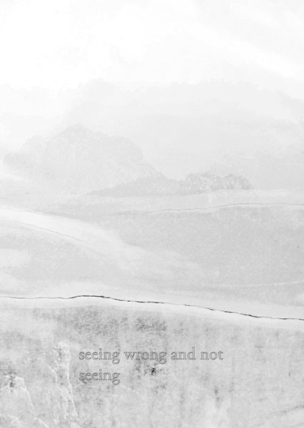
Seeing wrong and not seeing
10.12.2010 - 29.1.2011
In the show "seeing wrong and not seeing", the artist group Mahony combines its own experiences with current and historical geopolitical questions. In contrast to projects predating the current trip, the map material, its historical development and its use up to today become the starting point for the show. Maps do not depict reality, rather they reveal the way it is constructed. The show by the artist group Mahony - consisting of Clemens Leuschner, Stephan Kobatsch and Jenny Wolka - is inspired by this process.
This place that cannot be located but that is present according to the image, is based on the multi-part series "Nearest Neighbour" (2010). Found visual motifs of various landscapes are collaged together and visually unified using a white silkscreen layer. Despite the location sources being used in different ways, the details of the geographical landmarks - such as the course of the mountain range - are chosen in such a way that the corresponding images complement each other and form a whole. If maps do not represent reality, but rather its construction, this work could correspond to the production sequence of a coast-line calculated using mathematical vectors, which becomes evident not through image points but through connection points. The individual images, however, reveal another problem: that of political exploitation. In the following, the artists make the connections, but the individual images show areas whose political affiliation has not been agreed upon by the negotiating parties.
Whether it makes sense to reproduce a map that does not correspond to the image is the main theme of the artist group Mahony's piece "seeing wrong and not seeing", from which the show takes its title. Two folding maps - both made of canvas on folded aluminium - face each other. A circle that was actually not meant to be there, but which the viewer recognises as a coffee stain, provides the most distinctive geometrical hint on the map that is there for purposes of orientation. Its magnified reproduction served as model for the map lying on the table. Through corrections, overpainting and subtractions it clearly shows the painter's intervention, that is, to expose the map to a subjective shift in the process of copying.
The piece "Vollkommen und absolut Weiß" (2010) logically follows by dealing with the irrelevance of representing the world. Lewis Carroll developed a completely white and empty nautical chart, whose marginal markings still contains the usual direction settings and subdivisions, but no markings that could be interpreted as flow directions, islands or coasts. According to Michael Glasmeier, Carroll's monochromatic surface does not signify a lack of orientation, but rather underlines the placelessness which "more than any maritime painting expresses the feelings seafarers have always had on the ocean. Despite all oceanographic survey and ship-related safety the traveller is still surrounded by an impressive solitude in the face of such boundlessness.(...)This is why Carroll's illustration, precisely because it does not show anything, is closer to the actual experience on the sea than any cartography, as precise as it may be."
The group submitted to that experience in the previous show project "Kimm Sun Sinn", when it undertook a 21-day passage on a container ship to the "New World" and examined the experience of historical travel compared to the current routes of global commerce. Despite the clear ocean streams and the clear flow of commodities, here too there is a basic feeling of solitude, based on the monotony of a horizon that remained almost unchanged over days. Arthur C. Danto completes the quote above: "You can say of a map that is a duplicate, with the help of which we can find our way in a certain kind of reality, but as Lewis Carroll has shown, the map cannot be the duplicate of the country, or we would lose our way in one and in the other." And still we think that as soon as the itinerary has been calculated by nautical instruments, nothing is left to chance and we can find our way without peril. In a world measured by and encountered through sonar, GPS and satellite navigation, the myths of seafaring cannot be fuelled by maps anymore, no matter whether these myths are based on reality or not. "The imaginary plays no part in the world's text, in the way monsters still did in the illustrations on the margins of Gothic manuscripts and early maps". In the context of the show the artist group complements the illustrations in the margins described above with a shelf fixed on the floor, on which sea-monsters sit in a row, as if waiting to be deployed all over the world, in the piece "Shelf Dummies" (2010).
If one continues Glasmeier's train of thought from the year 1997, the pixelled Google Earth entries on the digitally retrievable maps on the internet take the place of the medieval descriptions of sea-monsters. The pieces cast in concrete "diskreter Stapel" (2010) and "diskrete Fläche" (2010) are derived through these graphic images from Google Earth. The horizontal and stacked showcase building blocks correspond to the pixels taken from the internet, which render areas unrecognisable in advance based on their security or secrecy status.
So, on a next level, the principle of subjectively created maps with their objective standard of wanting to reproduce the world is lead ad absurdum. In the show these concrete casts of the quintessentially most secret and the most unspectacular places become new markers, which discreetly open the show to the visitor. The two-dimensional pixelled landscape is translated in the show into a three-dimensional sculpture that can be set up in different ways, but again mirrors the space of the map drawn into the surface in the next possible dimension.
Historical cartography was always influenced and characterised by the artist's subjective mark and the monarchs who initiated the projects. Due to the reproduction of maps by machines, we have lost the perception for the fact that maps are still designed according to subjective and political criteria. To extend its sphere of influence, the Japanese government has invested millions in the last 60 years, to save a small inaccessible island from sinking, due to natural causes. Even the island's representation on the map is not on the same scale as the neighbouring islands, because such a small dot cannot be displayed in a readable fashion. Using cartography as an example, the exhibition deals with artistic and political criteria to authentically represent the world and it shows the conflicting limits between fiction and reality to be shifting and absurd.
Karin Pernegger, Krems January 2011
English translation by Douglas Montjoye